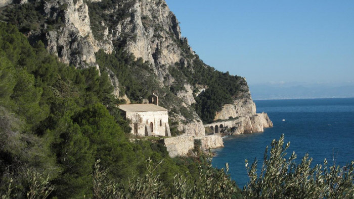
Between Punta Crena and Cape Noli: Exploring Their Sea-Facing Caves.
The Ligurian Riviera di Levante offers visitors stunning cliffs overlooking the sea: from Camogli to the Gulf of Poets, a series of promontories, points, and rocky cliffs plunge into the water, some more elevated than others.
Even the Western Ligurian coast has its wild stretches overlooking the sea: between Spotorno and Varigotti, high limestone rocks touch the coast, to the extent that the name “Malpasso” (difficult passage) indicates how challenging it was to move between the two localities.
Today, the Via Aurelia cuts through the cliffs and passes through a few tunnels to navigate the rugged terrain near Cape Noli. In the past, passage was only possible inland.
The adjective that best describes the landscape during this hike is “sunny“: you proceed through Mediterranean scrub or on very light rocks that reflect the sunlight. Not far from Varigotti, in a splendid location, you will also find a very ancient church called San Lorenzo. On the clear walls of the building, you can easily notice beautiful purple flowers, found only here and in Finalese and nowhere else in the world; it is the Campanula with equal leaves, easily recognisable to those who have read the naturalist signs placed at the beginning of the trail.
A steep trail leads to a cave: it’s the Grotta dei Falsari or dei Briganti (Cave of Forgers or Brigands). The name derives from the time when passage was restricted to this winding path: in particular, it is said that this nook was the secret hiding place of thieves who used it as a warehouse. The entrance to the cave, overlooking the sea, is downhill. The cavity has a wide opening towards the sea: a spectacular balcony on the coast through which light filters.
Near the starting point of the trail, at Punta Crena (a promontory that marks the western limit of the Bay of the Saracens), you will encounter the ruins of a castle and a watchtower against Saracen pirates.
The origins of the Church of San Lorenzo date back to an early Christian phase dating from the 3rd to 4th century. In 1944, it was severely damaged by a bomb dropped by the British Royal Air Force. Beyond the church, there is a wall that displays some picturesque ex-votos related to misfortunes related to navigation (Cerisola Mausoleum). Along the upper part of the trail, with a short detour, you will reach the “Torre delle Streghe” (Witches’ Tower), built in the 16th century on the border between Noli and Varigotti, at the time rival towns: Noli was an ally of the Republic of Genoa, while Varigotti belonged to the Marquisate of Finale dei Del Carretto. Other ruins along the path include the three churches of San Lazzaro, San Michele, and Santa Margherita, as well as the Hermitage of Captain D’Albertis.
The locality of Semaforo, located at 275 meters above sea level, houses a meteorological station. In the past, it served as a signaling and reference point for navigation.


