Discover the Alta Via dei Monti Liguri and its 24/7 online guide
440 kilometers from the Maritime Alps to the Apennines. Explore Liguria from Ventimiglia to Ceparana, on foot or by bike.
The Alta Via in Liguria is the perfect itinerary for everyone and can be hiked or biked all year round. Trails and mule tracks connect the two ends of the Ligurian Riviera, offering a journey between the coast and the inland, the Alps and the Apennines, the sea and the sky. Step by step, you’ll fall more and more in love with this land.
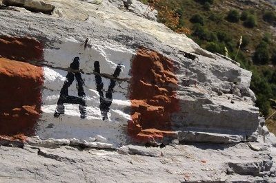
The red-white-red trail marker with the AV emblem designates a unique path from Riviera to Riviera, where you can simultaneously admire Corsica and Gorgona, Monviso, and the Massif of Monte Rosa.
For information and assistance, the Association Ospitalità Alta Via dei Monti Liguri provides a telephone information service called “Altaviainfoh24,” operational at any time, even on holidays, in English and French as well. Just call +39.338.16.29.347.
For additional information, you can find the online guide and services at www.altaviainfoh24.com.


